• Steel Soldiers now has a few new forums, read more about it at: New Munitions Forums!

  • Microsoft MSN, Live, Hotmail, Outlook email users may not be receiving emails. We are working to resolve this issue. Please add support@steelsoldiers.com to your trusted contacts.


2013 KAMO Rally Attendance thread, Kansas Arkansas Missouri Oklahoma

MWMULES

Well-known member
Steel Soldiers Supporter
In Memorial
5,580
344
83
Location
DESOTO, KANSAS
Kansas Arkansas Missouri Oklahoma Steel Soldiers Rally June 21-23 @ D-Day Adventure park is this coming week end and we need to try and get a handle on who all is coming and when you think you will get there. Even if you don't drive your MV come by and spend time with others who share this illness!


Map to Rally http://maps.google.com/maps?q=D-Day+...2&z=13&iwloc=A
D-DAY ADVENTURE PARK link http://www.ddaypark.com/
OFAST SHOW LINK http://www.oklahomafullauto.com/
Closest motel link www.indigoskycasino.com NOW BOOKED UP
Next closest motels are in Neosho Mo. http://maps.google.com/maps?oe=utf-8...&ved=0CM4BELYD


CLOSEST FAST FOOD AND GROCERY STORE IS IN Seneca, MO 8 MILES NORTH EAST.

swap thread http://www.steelsoldiers.com/showthread.php?108081-KS-AR-MO-OK-KAMO-Rally-parts-wanted-for-sale-swap-thread-2013&highlight=kamo

info thread http://www.steelsoldiers.com/showth...1-23-D-Day-Adventure-park-2013&highlight=kamo
 
Last edited:

Aswayze

Member
250
6
18
Location
Martinsburg Wv
I will be there friday late afternoon/evening. Catching a lift in with Flying Van who should have shannon with him. My M35A2 and M151A1 are both pre-staged down there along with Flying Van's m35a2 since we were all down this last weekend helping to move paintballers for the Oklahoma D-Day paintball event.

Should have Z and Curfman with me as well. Stagg is driving his CUCV down as well (I think) in addition to already having his Gaz-69M prestaged as well.

Tascabe should be along, I assume later friday night, he should have Trucker along who's not got his M37 done so will be hitchhiking with us. Tascabe has his Unimog as well as BTR-40 on site as well but the BTR has a spun rod so all we'll be doing with it is tugging it up onto the trailer with the Unimogs winch.

That is, I believe, all of the immediate East Wind crowd. I'll update if we get more.
 

jasonjc

Well-known member
5,325
283
83
Location
Gravette Ar.
I'm going to try to get there some time on saterday. I just need to try to find time between now and Saterday to pretrip/PMCS the deuce.
 

Flyingvan911

Well-known member
4,709
158
63
Location
Kansas City, MO
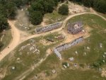
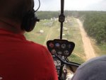
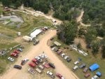
My dad might come by Saturday to see what's up. He might bring my little brother Ben and his son. Here are a few pics from the helo ride Aswayze, Shanon and I took during the paintball game Saturday. A pic of the parking area and my deuce, a pic of the town of Coleville (AKA Coalville, Collerville, etc). The park is huge.
 

Attachments

Aswayze

Member
250
6
18
Location
Martinsburg Wv
Ok some quick notes for everyone:

175 road takes you directly to the gate to D-Day park. On the way in you’ll pass a CJ-2a and an old car painted up like a staff car. Just past that you’ll see a ward container (expando van body) sitting alongside the roadway. Usually, if I am driving a bigger truck or have a decent amount of weight on, I’ll stop here and put the truck in low range. There are two fairly steep grades just past this container and although the road is well maintained, paved, etc, being in low range lets me tractor up and down the hills with relative ease. Besides, past this point, I’ll not need high range anyhow since I am coming to DDAP to off road anyhow and the big trucks are much more pleasant to trundle around off road with in low range.


Cayuga Road has a low water bridge on it that **sort of** has a 2 ton limit. I say sort of because it was redesignated as a 2 ton bridge because some of the local residents wanted to get rid of tractor trailer traffic on their road and since they knew the county bridge guy… Well, you know how this sort of thing goes. At any rate, if you are inclined to want to avoid the 2 ton bridge, you’ll need to come in from the state highway 10 side which to be honest is a lot more pleasant drive in anyhow. Most of us who are coming from KC, Tulsa and points west tend to come in this way anyhow.

Here’s how to get in that way:

From US-60 head south on State Highway 10. You’ll turn left onto 160 road just up the hill a ways and follow 160 down into a valley where at a church you’ll turn right onto 670 road along with obviously every other car that’s ever come through here… (really obvious turn) across the bridge, you’ll turn left onto 166 road again taking the CLEARLY obvious route. 166 with take you along the edge of nice little valley where if you look to the left you’ll see a massive Eagle nest before taking you to a T-junction with Cayuga road just past where the 2 ton bridge is. Turn right on Cayuga, then after a short distance you’ll see the D-Day sign and take a right on 175 road. Ta-da, you’re there.


Some specific route notes for the KC guys. As many of you know, I drive this route about 10-15 times a year with my Deuce so I know it well. I have found that taking US 69 is MUCH more pleasant route in than taking I-49. Unless, like Jwright, you just happen to live right off of I-49 on the south side of town I cannot recommend enough taking US-69 instead.

Here’s the route I use:

US-69 south to US 69Alt (follow the signs towards Baxter Springs)
Cross into Oklahoma and go through the little town of Quapaw and just past the increasingly defunct Antique Auto Museum, turn left onto 137 road.

Follow 137 past Shawnee Junction ignoring State Highway 10 at this junction, and down through the Twin Bridges State Park till it deposits you right at US-60. Turn left on 60 and note the Turtle Stop truck stop on the right just past the Casino. For those of you with older gas vehicles, it is worth noting that Turtle Stop sells ethanol free gas so it’s a good spot to fill up at if you’re trying to avoid ethanol troubles. Past Turtle Stop, you’ll come to State Highway 10 again where you’ll turn right. From here, follow the above instructions in.

Other general route notes for US-69:

Pichlers Chicken Annies just south of Pittsburg is a good place to eat and has ample parking for a convoy of big trucks.

Woods in Ft. Scott has Diesel and ample room to maneuver, you can easily walk over to McDonalds from there as well.

You can stop at the McDonalds in Baxter Springs with 1 or 2 bigger trucks but it gets tight if you have many more or if they are busy. The Walmart parking lot right there is signed No Trucks although we frequently will use it if we don’t have big loads on or trailers.
 

Aswayze

Member
250
6
18
Location
Martinsburg Wv
For those of you who have not been, DDAP is used for HUGE events and as such has a quite sizable campground. We’ve pretty much got the whole place to ourselves this coming weekend so there is no reason not to cherry pick the nicest spot to hang out at.

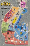
Attached here you’ll see the D-Day Paintball event campground map that I have modified using MS Paint to show the basic area we’ll want to set up in.

It’s a nice treed spot that offers good shade and decent breezes as well as decent access to both sets of restrooms and shower houses. It also places us right by the RV camping so it’s a snap for us to get electricity or water hook ups if someone wants. The paintball event was the weekend before and as you can well imagine placing 4000 people in one campground can generate a bit of a mess but Tascabe, David, and I ran through this area on Sunday before we left and picked that spot up pretty well. Not everyone was out of there but as long as the last ones out were not total heels, the area should still be in good shape.

This area will EASILY fit all of us with room to spare.

If the map is not obvious, here’s the directions:

When you come in the park, go past the registration building and turn left under the D-Day sign, as you head up this road, look to your right at the tree line. That’s the spot, just noodle your way on back and slip into the trees and you’re all set.

If you’re a maps sort of person, you can grab one of the East Wind event maps from the East Wind site here: http://www.operationeastwind.com/maps/EventFields/DDAP-NATO-24x36.pdf I’ll also have some paper copies on hand since part of what we are going to do this weekend is update the maps a bit.
 

Attachments

Aswayze

Member
250
6
18
Location
Martinsburg Wv
Of course, Fireman. Bring em on!

We're bringing easily 2x as many of us as we have trucks anyhow (and we have LOT of trucks)

There's plenty to do down there and the 4 wheeling is more fun when you have someone with you.
 

Aswayze

Member
250
6
18
Location
Martinsburg Wv
Since I’ll not be there till Friday afternoon and then will be running off with Brett first thing Saturday to go pick up another truck over in Nowata Oklahoma (we’ll be right back) I figure I would hit you guys with some quick trail notes so that you all can get out and 4 wheel away.

I will preface this by saying that you do not NEED to know any of this to 4-wheel successfully at DDAP, the trails are all pretty obvious and since the ground down there is made of clay, dust and rocks you really have to do something daffy to really get stuck.

Reference the map in the post above.

The main trail entrance is marked there on the campground map and has a pair of big concrete pipes marking it.

Where you enter the trail system at is a small MOUT village refered to as Caen by the paintballers. Here they have constructed buildings out of repurposed dock foam that they then spray with Gunnite. You’ll see these types of building all over the place out there, they really do look good and work perfectly for what they use them for.

Anyhow, this gets you on the trails so from here I’ll give you some notes by road number:

17 15 27 19 183 10 and 11 roads are all main roads. You could drive your family sedan down these roads and in many places they are wide enough for school busses to pass each other in (Because they use school busses at the Paintball event) You can run all over on these roads and not really run into trouble. You’ll find some steep hills from time to time but nothing crazy.

21 22 23 231 are all feeder roads/trails in an area called “the 210” this is a scenic valley that makes up the western portion of the property. These are all easily passable roads for a 4x4 which are fairly clear of scratchy bushes that you guys can run all over and not have to worry about scratching things up. Make sure to check out the views from some of the hilltops out there and be on the lookout for wild raspberries which abound.

25 road south of the intersection of 27 road Down here 25 is a fire road that runs directly north south along the fence that separates the 210 from the rest of the place. It is a ROUGH road with steep hills and fist sized rocks. Big trucks manage 25 with relative ease since it is fairly open and wide and the steep angles don’t cause diesel engines to sputter like the gas engines do. Most of 25 should be quite passable but make sure you send a SINGLE recon vehicle down the last gully to the south before you all jump in there, it gets washed from time to time and may need a little pick work to be really passable. David, Jwright, and I love driving that area in our deuces. Be careful on 25 with smaller trucks and avoid the temptation to drive fast to make the hills since the large rocks can beat the stuffin out of your axles if you’re not careful.

25 road north of the intersection of 27 road. Up here, 25 cuts into the forest and drops down into a little valley before ascending the opposite side in an area called “the lost 40” There are a number of little trails in this area that are a lot of fun to run around in if you have CUCV or smaller vehicles and 25 itself is pretty fun as well. It’s steep but the road bed is good and as long as you’re in 4 (or 6) wheel drive, it’s easy to manage. Not so many loose stones down in here so not much worry about damage to your truck.

Most all of the roads and trails in the central area are pretty passable, just run around to your hearts content. My only caution here is the iron bridge on the loop trail off of 15 is a serious bridge but not really one you’ll want to drive a big truck across since the decking is plenty old.

The north area is the “enemy” side of the border for me at East Wind so I don’t really know those trails all that well. Like anywhere though, just drive it and if it gets spooky, turn around and go back. I have driven around all over the place up there but I don’t know it well enough that I feel confident just doling out advise.

Anyhow, that should give you guys some useful notes in case you’re looking for someplace to go on your own and there isn’t one of us around who knows the place.

#1 thing guys.

Have fun out there, this is a great place to go run around at, get out there and make the most of it!
 

Attachments

Top
AdBlock Detected

We get it, advertisements are annoying!

Sure, ad-blocking software does a great job at blocking ads, but it also blocks useful features of our website like our supporting vendors. Their ads help keep Steel Soldiers going. Please consider disabling your ad blockers for the site. Thanks!

I've Disabled AdBlock
No Thanks